Phillaur night lights from space
Night Light of Phillaur (Punjab) from space (India) Src. Average luminocity for 10x10km area is 36.8407% and for 50x50km: 30.061%.

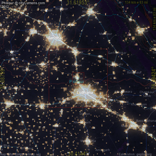
Analysis of Phillaur night lights 2016
Square area 10x10 km:
 2.38%
2.38%90-99
8.61%80-89
1.83%70-79
1.65%60-69
4.4%50-59
6.96%40-49
9.52%30-39
9.89%20-29
19.96%10-19
30.4%0-9
4.4%Square area 50x50 km:
5.52%90-99
6.82%80-89
3.23%70-79
2.26%60-69
3.57%50-59
4.36%40-49
4.94%30-39
4.87%20-29
7.7%10-19
13.32%0-9
43.4%Clear (daylight) street map image can be seen on geolist.org.
Map coordinates:
31° 37' 10.3" North, 75° 5' 16.8" East
31° 1' 7.9" North, 75° 47' 28" East
30° 24' 51.8" North, 76° 29' 39.3" East
Some cities around Phillaur sort by population:
• Ludhiāna
13.3 km =8.3 mi,  153°
153°
• Phagwāra
22.9 km =14.2 mi,  355°
355°
• Nakodar
32.4 km =20.1 mi,  291°
291°
• Jandiāla
22.7 km =14.1 mi,  313°
313°
• Dorāha
33 km =20.5 mi,  137°
137°
• Banga
27.1 km =16.8 mi,  45°
45°
• Nūrmahal
20.7 km =12.9 mi, 294°
• Rāhon
31.5 km =19.6 mi,  83°
83°
1259775 (p: 22,588)
Sources (retrieved 2019-11-25):
» Earth at Night: Flat Maps 2012, 2016