Rāmpura night lights from space
Night Light of Rāmpura (Uttar Pradesh) from space (India) Src. Average luminocity for 10x10km area is 5.0341% and for 50x50km: 6.4344%.
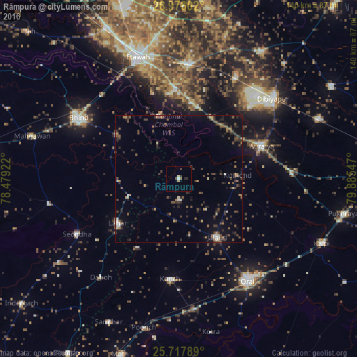
Analysis of Rāmpura night lights 2016
Square area 10x10 km:
 0.38%
0.38%90-99
0.38%80-89
0.76%70-79
0%60-69
0.76%50-59
0.76%40-49
1.89%30-39
0.76%20-29
1.52%10-19
0.38%0-9
92.42%Square area 50x50 km:
0.26%90-99
0.49%80-89
0.39%70-79
0.6%60-69
1.08%50-59
1.17%40-49
1.7%30-39
1.64%20-29
1.93%10-19
2.68%0-9
88.05%Clear (daylight) street map image can be seen on geolist.org.
Map coordinates:
26° 58' 40.9" North, 78° 28' 45.2" East
26° 20' 58.8" North, 79° 10' 56.4" East
25° 43' 4.4" North, 79° 53' 7.7" East
Some cities around Rāmpura sort by population:
• Jālaun
27.5 km =17.1 mi,  145°
145°
• Lahār
29.6 km =18.4 mi,  234°
234°
• Mihona
21.4 km =13.3 mi,  249°
249°
• Bakewar
34.8 km =21.6 mi,  359°
359°
• Lakhnā
33.4 km =20.8 mi,  354°
354°
• Mādhogarh
8.3 km =5.2 mi,  177°
177°
• Umri
30.3 km =18.8 mi,  306°
306°
• Nadīgaon
31.2 km =19.4 mi,  210°
210°
1258590 (p: 11,347)
Sources (retrieved 2019-11-25):
» Earth at Night: Flat Maps 2012, 2016