Alīganj night lights from space
Night Light of Alīganj (Uttar Pradesh) from space (India) Src. Average luminocity for 10x10km area is 3.7361% and for 50x50km: 6.6335%.
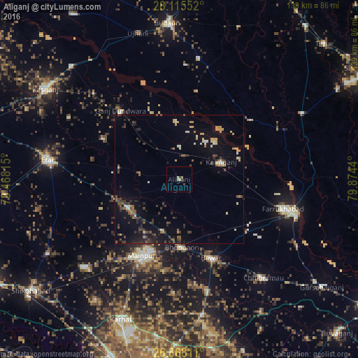
Analysis of Alīganj night lights 2016
Square area 10x10 km:
 0%
0%90-99
0%80-89
0.79%70-79
0.79%60-69
1.59%50-59
0%40-49
0.79%30-39
0.79%20-29
0.79%10-19
0%0-9
94.44%Square area 50x50 km:
0.18%90-99
0.74%80-89
0.6%70-79
1.08%60-69
0.54%50-59
0.96%40-49
1.28%30-39
1.59%20-29
1.48%10-19
4.83%0-9
86.73%Clear (daylight) street map image can be seen on geolist.org.
Map coordinates:
28° 6' 55.9" North, 78° 28' 5.3" East
27° 29' 36.9" North, 79° 10' 16.6" East
26° 52' 5.2" North, 79° 52' 27.8" East
Some cities around Alīganj sort by population:
• Mainpuri
32.7 km =20.3 mi,  205°
205°
• Kaimganj
17.5 km =10.9 mi,  67°
67°
• Bhongaon
26.5 km =16.5 mi,  177°
177°
• Shamsābād
26.7 km =16.6 mi,  79°
79°
• Bewar
33 km =20.5 mi,  157°
157°
• Muhammadābād
33 km =20.5 mi,  128°
128°
• Patiāli
27.8 km =17.3 mi,  322°
322°
• Kampil
16.8 km =10.4 mi,  38°
38°
1279023 (p: 26,652)
Sources (retrieved 2019-11-25):
» Earth at Night: Flat Maps 2012, 2016