patamda night lights from space
Night Light of patamda (Jharkhand) from space (India) Src. Average luminocity for 10x10km area is 39.6174% and for 50x50km: 20.5712%.
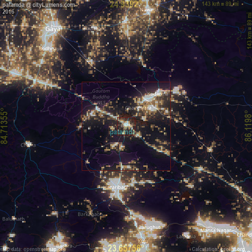
Analysis of patamda night lights 2016
Square area 10x10 km:
 4.17%
4.17%90-99
4.17%80-89
4.36%70-79
5.68%60-69
5.68%50-59
5.3%40-49
5.87%30-39
13.45%20-29
20.08%10-19
31.25%0-9
0%Square area 50x50 km:
1.75%90-99
2.83%80-89
1.76%70-79
2.35%60-69
2.61%50-59
3.04%40-49
3.95%30-39
4.2%20-29
7.8%10-19
21.01%0-9
48.71%Clear (daylight) street map image can be seen on geolist.org.
Map coordinates:
24° 56' 21.1" North, 84° 42' 48.8" East
24° 18' 0" North, 85° 25' 0" East
23° 39' 27.2" North, 86° 7' 11.3" East
Some cities around patamda sort by population:
• Hazāribāgh
34.7 km =21.6 mi,  189°
189°
• Bagaha
44.2 km =27.5 mi,  305°
305°
• Jumri Tilaiyā
18.9 km =11.7 mi,  37°
37°
• Chatrā
56.3 km =35 mi,  259°
259°
• Barki Saria
49.9 km =31 mi,  106°
106°
• Kodarmā
25.9 km =16.1 mi, 43°
• Dhanwār
58.6 km =36.4 mi,  77°
77°
• Hesla
53.8 km =33.4 mi,  119°
119°
1276955 (p: 10,655)
Sources (retrieved 2019-11-25):
» Earth at Night: Flat Maps 2012, 2016