Dhanwār night lights from space
Night Light of Dhanwār (Jharkhand) from space (India) Src. Average luminocity for 10x10km area is 0.6786% and for 50x50km: 1.6042%.
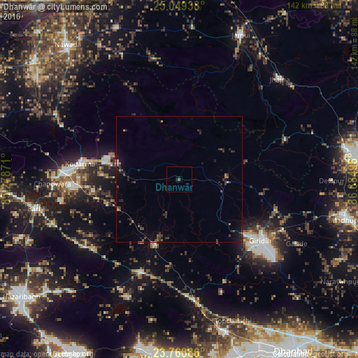
Analysis of Dhanwār night lights 2016
Square area 10x10 km:
 0%
0%90-99
0%80-89
0%70-79
0%60-69
0%50-59
0.79%40-49
0%30-39
0%20-29
0.2%10-19
1.39%0-9
97.62%Square area 50x50 km:
0%90-99
0.03%80-89
0.06%70-79
0.11%60-69
0.23%50-59
0.24%40-49
0.46%30-39
0.74%20-29
0.75%10-19
1.07%0-9
96.3%Clear (daylight) street map image can be seen on geolist.org.
Map coordinates:
25° 2' 57.8" North, 85° 16' 43.4" East
24° 24' 38.7" North, 85° 58' 54.6" East
23° 46' 7.9" North, 86° 41' 5.9" East
Some cities around Dhanwār sort by population:
• Jumri Tilaiyā
45.9 km =28.5 mi,  273°
273°
• Gīrīdīh
41.5 km =25.8 mi,  126°
126°
• Jhā-Jhā
56.7 km =35.2 mi,  45°
45°
• Barki Saria
27.7 km =17.2 mi,  199°
199°
• Kodarmā
39.8 km =24.7 mi,  279°
279°
• patamda
58.6 km =36.4 mi,  257°
257°
• Hesla
40 km =24.9 mi, 195°
• Topchānchi
60.5 km =37.6 mi,  158°
158°
1272902 (p: 8,512)
Sources (retrieved 2019-11-25):
» Earth at Night: Flat Maps 2012, 2016