Parshādepur night lights from space
Night Light of Parshādepur (Uttar Pradesh) from space (India) Src. Average luminocity for 10x10km area is 14.5198% and for 50x50km: 22.2647%.
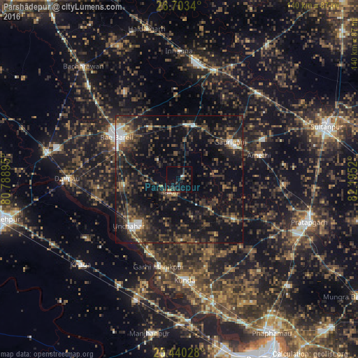
Analysis of Parshādepur night lights 2016
Square area 10x10 km:
 0.79%
0.79%90-99
0.79%80-89
0.79%70-79
0.79%60-69
0%50-59
2.38%40-49
4.96%30-39
3.97%20-29
5.16%10-19
17.66%0-9
62.7%Square area 50x50 km:
1.29%90-99
1.74%80-89
0.97%70-79
1.49%60-69
2.22%50-59
3.92%40-49
6.57%30-39
8.04%20-29
10.96%10-19
24.38%0-9
38.44%Clear (daylight) street map image can be seen on geolist.org.
Map coordinates:
26° 42' 12.2" North, 80° 47' 20.2" East
26° 4' 24.7" North, 81° 29' 31.5" East
25° 26' 25" North, 82° 11' 42.7" East
Some cities around Parshādepur sort by population:
• Raebareli
31.2 km =19.4 mi,  304°
304°
• Jais
22 km =13.7 mi,  14°
14°
• Kunda
39.7 km =24.7 mi,  176°
176°
• Lālganj
26.5 km =16.5 mi,  126°
126°
• Salon
6.3 km =3.9 mi,  217°
217°
• Amethī
32.6 km =20.3 mi,  73°
73°
• Antu
41.1 km =25.5 mi,  92°
92°
• Mahārājganj
40.5 km =25.2 mi,  327°
327°
1260249 (p: 10,690)
Sources (retrieved 2019-11-25):
» Earth at Night: Flat Maps 2012, 2016