Kunda night lights from space
Night Light of Kunda (Uttar Pradesh) from space (India) Src. Average luminocity for 10x10km area is 56.4394% and for 50x50km: 32.0926%.
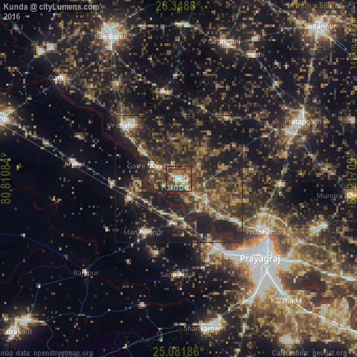

Analysis of Kunda night lights 2016
Square area 10x10 km:
 4.17%
4.17%90-99
7.39%80-89
5.11%70-79
10.42%60-69
15.72%50-59
9.28%40-49
20.45%30-39
20.64%20-29
6.25%10-19
0.57%0-9
0%Square area 50x50 km:
1.06%90-99
2.28%80-89
2.39%70-79
3.84%60-69
4.75%50-59
7.52%40-49
10.5%30-39
11.55%20-29
14.24%10-19
28.95%0-9
12.91%Clear (daylight) street map image can be seen on geolist.org.
Map coordinates:
26° 20' 55.7" North, 80° 48' 39" East
25° 43' 1.3" North, 81° 30' 50.3" East
25° 4' 54.7" North, 82° 13' 1.5" East
Some cities around Kunda sort by population:
• Lālganj
30.6 km =19 mi,  38°
38°
• Sarāi Ākil
37.6 km =23.4 mi,  180°
180°
• Manjhanpur
25 km =15.5 mi,  213°
213°
• Bharwāri
17.5 km =10.9 mi,  187°
187°
• Karārī
30.7 km =19.1 mi,  196°
196°
• Salon
35.2 km =21.9 mi,  350°
350°
• Sirāthu
21.2 km =13.2 mi,  247°
247°
• Chail
34.4 km =21.4 mi,  159°
159°
1265632 (p: 24,948)
Sources (retrieved 2019-11-25):
» Earth at Night: Flat Maps 2012, 2016