Pānsemāl night lights from space
Night Light of Pānsemāl (Madhya Pradesh) from space (India) Src. Average luminocity for 10x10km area is 8.5985% and for 50x50km: 2.8268%.
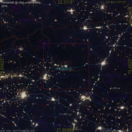
Analysis of Pānsemāl night lights 2016
Square area 10x10 km:
 0%
0%90-99
1.52%80-89
1.33%70-79
0.95%60-69
1.52%50-59
0%40-49
0.19%30-39
4.36%20-29
3.79%10-19
1.89%0-9
84.47%Square area 50x50 km:
0.06%90-99
0.39%80-89
0.46%70-79
0.31%60-69
0.34%50-59
0.42%40-49
0.45%30-39
0.66%20-29
0.93%10-19
1.36%0-9
94.61%Clear (daylight) street map image can be seen on geolist.org.
Map coordinates:
22° 18' 42.5" North, 73° 59' 46.5" East
21° 39' 35.3" North, 74° 41' 57.7" East
21° 0' 17.5" North, 75° 24' 9" East
Some cities around Pānsemāl sort by population:
• Shirpur
39.4 km =24.5 mi,  151°
151°
• Shāhāda
26.8 km =16.7 mi,  241°
241°
• Sendhwa
41.1 km =25.5 mi,  85°
85°
• Barwāni
46.3 km =28.8 mi,  26°
26°
• Dondaicha
39.8 km =24.7 mi,  199°
199°
• Taloda
51.5 km =32 mi,  257°
257°
• Rajpur
54.8 km =34.1 mi,  55°
55°
• Khetia
11.9 km =7.4 mi,  276°
276°
1260447 (p: 11,183)
Sources (retrieved 2019-11-25):
» Earth at Night: Flat Maps 2012, 2016