Rajpur night lights from space
Night Light of Rajpur (Madhya Pradesh) from space (India) Src. Average luminocity for 10x10km area is 5.9425% and for 50x50km: 4.1629%.
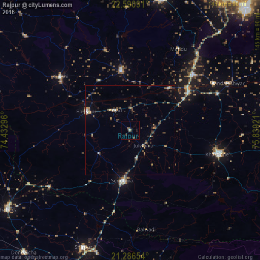
Analysis of Rajpur night lights 2016
Square area 10x10 km:
 0%
0%90-99
0.79%80-89
0.4%70-79
0.4%60-69
0%50-59
2.58%40-49
2.18%30-39
0.4%20-29
2.58%10-19
2.18%0-9
88.49%Square area 50x50 km:
0.04%90-99
0.55%80-89
0.28%70-79
0.36%60-69
0.54%50-59
0.8%40-49
1.11%30-39
1.19%20-29
1.17%10-19
1.16%0-9
92.8%Clear (daylight) street map image can be seen on geolist.org.
Map coordinates:
22° 35' 27.3" North, 74° 25' 58.7" East
21° 56' 24.8" North, 75° 8' 9.9" East
21° 17' 11.5" North, 75° 50' 21.2" East
Some cities around Rajpur sort by population:
• Khargone
51 km =31.7 mi,  104°
104°
• Sendhwa
28.6 km =17.8 mi,  188°
188°
• Barwāni
26.4 km =16.4 mi,  292°
292°
• Dhāmnod
45.6 km =28.3 mi,  49°
49°
• Manāwar
33.2 km =20.6 mi,  351°
351°
• Kukshi
49 km =30.4 mi,  307°
307°
• Anjad
14 km =8.7 mi,  323°
323°
• Dharampuri
31.7 km =19.7 mi,  42°
42°
1258816 (p: 19,396)
Sources (retrieved 2019-11-25):
» Earth at Night: Flat Maps 2012, 2016