Neral night lights from space
Night Light of Neral (Maharashtra) from space (India) Src. Average luminocity for 10x10km area is 23.0693% and for 50x50km: 28.1627%.
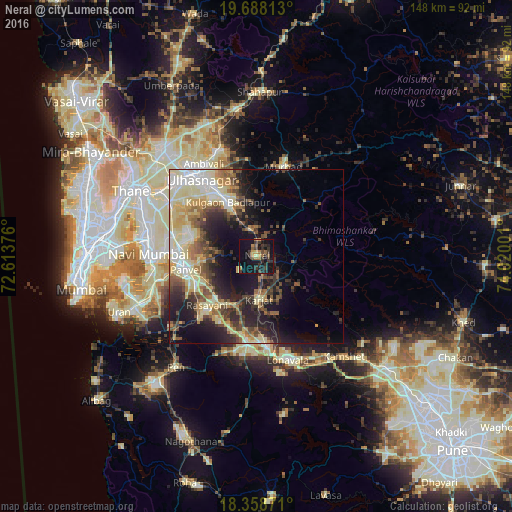
Analysis of Neral night lights 2016
Square area 10x10 km:
 0%
0%90-99
0.22%80-89
1.95%70-79
3.25%60-69
4.55%50-59
4.11%40-49
3.03%30-39
12.55%20-29
8.87%10-19
31.39%0-9
30.09%Square area 50x50 km:
2.81%90-99
5.91%80-89
6.18%70-79
3.25%60-69
3.4%50-59
3.83%40-49
4.06%30-39
4.5%20-29
7.08%10-19
12.63%0-9
46.34%Clear (daylight) street map image can be seen on geolist.org.
Map coordinates:
19° 41' 17.3" North, 72° 36' 49.5" East
19° 1' 29.1" North, 73° 19' 0.8" East
18° 21' 31.4" North, 74° 1' 12" East
Some cities around Neral sort by population:
• Amarnāth
25.1 km =15.6 mi,  320°
320°
• Panvel
22.1 km =13.7 mi,  259°
259°
• Badlapur
15.5 km =9.6 mi,  339°
339°
• Khopoli
26.8 km =16.7 mi,  173°
173°
• Karjat
12.7 km =7.9 mi,  176°
176°
• Murbād
26.6 km =16.5 mi,  16°
16°
• Kālundri
20.6 km =12.8 mi, 256°
• Mātherān
7.2 km =4.5 mi,  229°
229°
1261512 (p: 16,060)
Sources (retrieved 2019-11-25):
» Earth at Night: Flat Maps 2012, 2016