Rasūlābād night lights from space
Night Light of Rasūlābād (Uttar Pradesh) from space (India) Src. Average luminocity for 10x10km area is 3.4048% and for 50x50km: 12.282%.
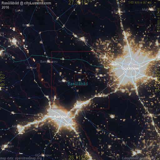
Analysis of Rasūlābād night lights 2016
Square area 10x10 km:
 0%
0%90-99
0%80-89
0%70-79
0.4%60-69
1.19%50-59
0.79%40-49
1.59%30-39
0%20-29
0.79%10-19
0.6%0-9
94.64%Square area 50x50 km:
0.95%90-99
1.92%80-89
1.1%70-79
1.36%60-69
1.37%50-59
2%40-49
2.55%30-39
2.7%20-29
4.73%10-19
8.99%0-9
72.31%Clear (daylight) street map image can be seen on geolist.org.
Map coordinates:
27° 22' 15.9" North, 79° 47' 13.2" East
26° 44' 41.7" North, 80° 29' 24.4" East
26° 6' 55" North, 81° 11' 35.7" East
Some cities around Rasūlābād sort by population:
• Unnāo
22 km =13.7 mi,  180°
180°
• Jagdīshpur
5.5 km =3.4 mi,  84°
84°
• Safīpur
14.6 km =9.1 mi,  266°
266°
• Mohān
18.8 km =11.7 mi, 77°
• Bithūr
26.7 km =16.6 mi,  234°
234°
• Aurās
18.9 km =11.7 mi,  5°
5°
• Ugu
17.8 km =11.1 mi,  288°
288°
• Fatehpur Chaurāsi
22.8 km =14.2 mi,  282°
282°
1258375 (p: 7,800)
Sources (retrieved 2019-11-25):
» Earth at Night: Flat Maps 2012, 2016