Fatehpur Chaurāsi night lights from space
Night Light of Fatehpur Chaurāsi (Uttar Pradesh) from space (India) Src. Average luminocity for 10x10km area is 1.7976% and for 50x50km: 3.5934%.
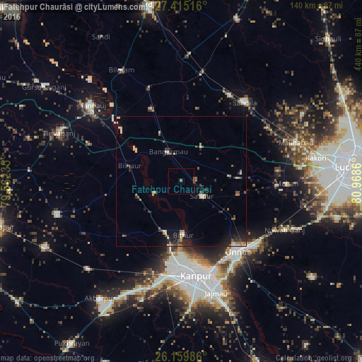
Analysis of Fatehpur Chaurāsi night lights 2016
Square area 10x10 km:
 0%
0%90-99
0%80-89
0%70-79
0.6%60-69
0.99%50-59
0.4%40-49
0%30-39
0%20-29
0%10-19
0%0-9
98.02%Square area 50x50 km:
0.15%90-99
0.53%80-89
0.45%70-79
0.4%60-69
0.52%50-59
0.45%40-49
0.57%30-39
0.59%20-29
1.2%10-19
2.37%0-9
92.77%Clear (daylight) street map image can be seen on geolist.org.
Map coordinates:
27° 24' 54.6" North, 79° 33' 44.5" East
26° 47' 21.3" North, 80° 15' 55.7" East
26° 9' 35.5" North, 80° 58' 7" East
Some cities around Fatehpur Chaurāsi sort by population:
• Bāngarmau
12.5 km =7.8 mi,  334°
334°
• Safīpur
9.6 km =6 mi,  126°
126°
• Bilhaur
20.9 km =13 mi,  286°
286°
• Bithūr
20.3 km =12.6 mi,  178°
178°
• Ganj Murādābād
20.4 km =12.7 mi,  336°
336°
• Rasūlābād
22.8 km =14.2 mi,  102°
102°
• Aurās
27.8 km =17.3 mi,  59°
59°
• Ugu
5.6 km =3.5 mi,  81°
81°
1271902 (p: 5,931)
Sources (retrieved 2019-11-25):
» Earth at Night: Flat Maps 2012, 2016