Mustafābād night lights from space
Night Light of Mustafābād (Haryana) from space (India) Src. Average luminocity for 10x10km area is 23.6399% and for 50x50km: 22.3062%.
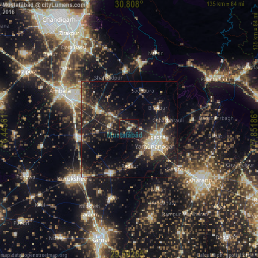
Analysis of Mustafābād night lights 2016
Square area 10x10 km:
 1.05%
1.05%90-99
1.57%80-89
0.87%70-79
3.5%60-69
0.87%50-59
6.12%40-49
5.59%30-39
7.34%20-29
9.09%10-19
40.38%0-9
23.6%Square area 50x50 km:
1.66%90-99
2.77%80-89
2.91%70-79
1.64%60-69
1.72%50-59
3.82%40-49
5.47%30-39
6.69%20-29
9.92%10-19
18.53%0-9
44.86%Clear (daylight) street map image can be seen on geolist.org.
Map coordinates:
30° 48' 28.8" North, 76° 26' 44.2" East
30° 12' 7.9" North, 77° 8' 55.4" East
29° 35' 33.5" North, 77° 51' 6.7" East
Some cities around Mustafābād sort by population:
• Yamunānagar
15.4 km =9.6 mi,  122°
122°
• Jagādhri
15.4 km =9.6 mi,  104°
104°
• Shāhābād
27 km =16.8 mi,  261°
261°
• Lādwa
25.2 km =15.7 mi,  203°
203°
• Radaur
19.5 km =12.1 mi,  179°
179°
• Chhachhrauli
20.9 km =13 mi,  76°
76°
• Bilāspur
18.8 km =11.7 mi,  52°
52°
• Būriya
20.7 km =12.9 mi, 103°
1262369 (p: 8,974)
Sources (retrieved 2019-11-25):
» Earth at Night: Flat Maps 2012, 2016