Bilāspur night lights from space
Night Light of Bilāspur (Haryana) from space (India) Src. Average luminocity for 10x10km area is 17.2253% and for 50x50km: 16.9086%.
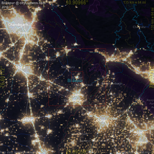
Analysis of Bilāspur night lights 2016
Square area 10x10 km:
 0.92%
0.92%90-99
2.38%80-89
0.18%70-79
2.56%60-69
0.92%50-59
2.38%40-49
4.4%30-39
2.75%20-29
8.06%10-19
19.23%0-9
56.23%Square area 50x50 km:
1.48%90-99
2.24%80-89
2.44%70-79
1.28%60-69
1.31%50-59
2.65%40-49
4.12%30-39
4.1%20-29
5.38%10-19
13.5%0-9
61.5%Clear (daylight) street map image can be seen on geolist.org.
Map coordinates:
30° 54' 34.8" North, 76° 36' 4" East
30° 18' 16.2" North, 77° 18' 15.3" East
29° 41' 44.1" North, 78° 0' 26.5" East
Some cities around Bilāspur sort by population:
• Yamunānagar
19.7 km =12.2 mi,  185°
185°
• Jagādhri
15.3 km =9.5 mi,  180°
180°
• Nāhan
28.5 km =17.7 mi,  358°
358°
• Narāyangarh
25.6 km =15.9 mi,  318°
318°
• Behat
33.2 km =20.6 mi,  116°
116°
• Chhachhrauli
8.5 km =5.3 mi,  140°
140°
• Būriya
17 km =10.6 mi,  162°
162°
• Mustafābād
18.8 km =11.7 mi,  232°
232°
1275633 (p: 10,709)
Sources (retrieved 2019-11-25):
» Earth at Night: Flat Maps 2012, 2016