Būriya night lights from space
Night Light of Būriya (Haryana) from space (India) Src. Average luminocity for 10x10km area is 52.3794% and for 50x50km: 25.149%.
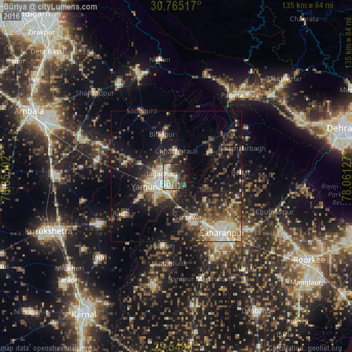
Analysis of Būriya night lights 2016
Square area 10x10 km:
 7.34%
7.34%90-99
15.73%80-89
7.87%70-79
5.77%60-69
3.67%50-59
7.52%40-49
8.39%30-39
10.14%20-29
11.19%10-19
14.51%0-9
7.87%Square area 50x50 km:
2.42%90-99
3.85%80-89
3.64%70-79
2.3%60-69
2.4%50-59
4.48%40-49
5.93%30-39
5.7%20-29
8.11%10-19
15.82%0-9
45.34%Clear (daylight) street map image can be seen on geolist.org.
Map coordinates:
30° 45' 54.6" North, 76° 39' 18.1" East
30° 9' 32.8" North, 77° 21' 29.3" East
29° 32' 57.5" North, 78° 3' 40.6" East
Some cities around Būriya sort by population:
• Yamunānagar
8 km =5 mi,  244°
244°
• Jagādhri
5.3 km =3.3 mi,  279°
279°
• Nakūr
27.1 km =16.8 mi,  190°
190°
• Behat
24.6 km =15.3 mi,  86°
86°
• Radaur
24.7 km =15.3 mi,  233°
233°
• Chhachhrauli
9.5 km =5.9 mi,  1°
1°
• Bilāspur
17 km =10.6 mi,  342°
342°
• Mustafābād
20.7 km =12.9 mi, 283°
1275053 (p: 10,641)
Sources (retrieved 2019-11-25):
» Earth at Night: Flat Maps 2012, 2016