Radaur night lights from space
Night Light of Radaur (Haryana) from space (India) Src. Average luminocity for 10x10km area is 17.6648% and for 50x50km: 24.1645%.
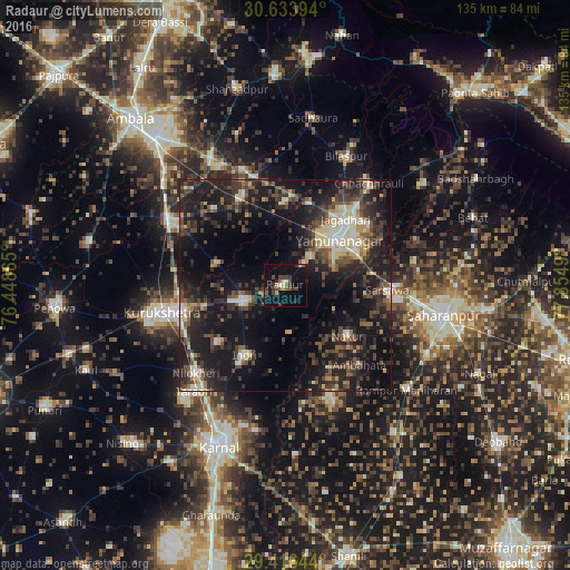
Analysis of Radaur night lights 2016
Square area 10x10 km:
 0.38%
0.38%90-99
1.14%80-89
2.27%70-79
1.14%60-69
1.14%50-59
3.79%40-49
5.87%30-39
5.87%20-29
3.03%10-19
12.69%0-9
62.69%Square area 50x50 km:
1.7%90-99
3.08%80-89
2.96%70-79
1.82%60-69
1.67%50-59
4.23%40-49
5.84%30-39
6.74%20-29
10.45%10-19
25.05%0-9
36.47%Clear (daylight) street map image can be seen on geolist.org.
Map coordinates:
30° 38' 2.2" North, 76° 26' 55.1" East
30° 1' 37.4" North, 77° 9' 6.4" East
29° 24' 59.2" North, 77° 51' 17.6" East
Some cities around Radaur sort by population:
• Yamunānagar
16.9 km =10.5 mi,  48°
48°
• Jagādhri
21.4 km =13.3 mi,  43°
43°
• Lādwa
10.9 km =6.8 mi,  249°
249°
• Nakūr
18.9 km =11.7 mi,  129°
129°
• Indri
18.6 km =11.6 mi,  208°
208°
• Ambahta
25.9 km =16.1 mi,  136°
136°
• Būriya
24.7 km =15.3 mi, 53°
• Mustafābād
19.5 km =12.1 mi,  359°
359°
1259075 (p: 12,328)
Sources (retrieved 2019-11-25):
» Earth at Night: Flat Maps 2012, 2016