Chhachhrauli night lights from space
Night Light of Chhachhrauli (Haryana) from space (India) Src. Average luminocity for 10x10km area is 24.9441% and for 50x50km: 19.9228%.
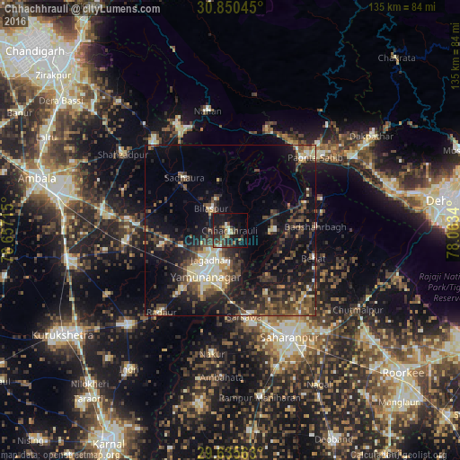
Analysis of Chhachhrauli night lights 2016
Square area 10x10 km:
 0.87%
0.87%90-99
4.02%80-89
1.75%70-79
1.4%60-69
3.15%50-59
3.85%40-49
5.07%30-39
8.22%20-29
14.51%10-19
27.1%0-9
30.07%Square area 50x50 km:
1.52%90-99
2.56%80-89
2.56%70-79
1.72%60-69
1.51%50-59
3.64%40-49
5.2%30-39
5.13%20-29
7.57%10-19
15.52%0-9
53.06%Clear (daylight) street map image can be seen on geolist.org.
Map coordinates:
30° 51' 1.6" North, 76° 39' 25.7" East
30° 14' 41.7" North, 77° 21' 37" East
29° 38' 8.3" North, 78° 3' 48.2" East
Some cities around Chhachhrauli sort by population:
• Yamunānagar
14.9 km =9.3 mi,  209°
209°
• Jagādhri
10.2 km =6.3 mi, 212°
• Pāonta Sāhib
33.1 km =20.6 mi,  49°
49°
• Behat
25.7 km =16 mi,  108°
108°
• Radaur
31.4 km =19.5 mi,  219°
219°
• Bilāspur
8.5 km =5.3 mi,  320°
320°
• Būriya
9.5 km =5.9 mi,  181°
181°
• Mustafābād
20.9 km =13 mi,  256°
256°
1274380 (p: 10,751)
Sources (retrieved 2019-11-25):
» Earth at Night: Flat Maps 2012, 2016