Moram night lights from space
Night Light of Moram (Maharashtra) from space (India) Src. Average luminocity for 10x10km area is 8.1082% and for 50x50km: 5.2369%.
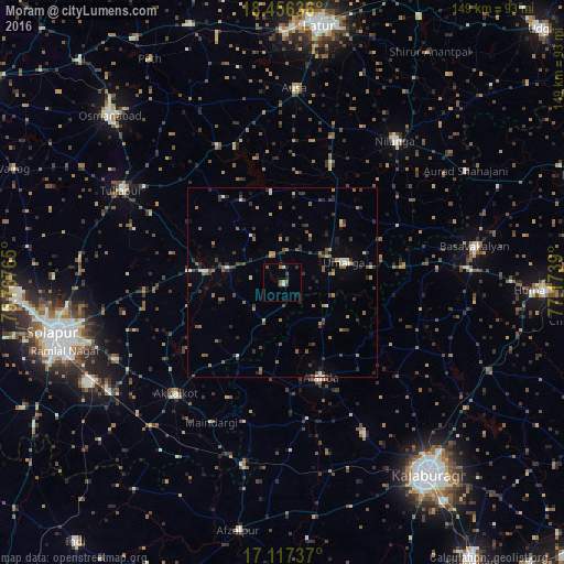
Analysis of Moram night lights 2016
Square area 10x10 km:
 0.22%
0.22%90-99
1.3%80-89
1.08%70-79
0%60-69
1.73%50-59
1.08%40-49
3.03%30-39
1.08%20-29
1.52%10-19
1.52%0-9
87.45%Square area 50x50 km:
0.18%90-99
0.43%80-89
0.49%70-79
0.43%60-69
0.89%50-59
1.07%40-49
1.04%30-39
1.45%20-29
1.52%10-19
1.01%0-9
91.47%Clear (daylight) street map image can be seen on geolist.org.
Map coordinates:
18° 27' 22.9" North, 75° 46' 3.5" East
17° 47' 17.2" North, 76° 28' 14.8" East
17° 7' 2.5" North, 77° 10' 26" East
Some cities around Moram sort by population:
• Akalkot
40.5 km =25.2 mi,  223°
223°
• Aland
27 km =16.8 mi,  157°
157°
• Tuljāpur
48.9 km =30.4 mi,  299°
299°
• Nilanga
47.2 km =29.3 mi,  39°
39°
• Umarga
17.1 km =10.6 mi,  70°
70°
• Naldurg
20.3 km =12.6 mi,  279°
279°
• Dudhani
49.1 km =30.5 mi,  192°
192°
• Maindargi
41.3 km =25.7 mi,  207°
207°
1262794 (p: 17,696)
Sources (retrieved 2019-11-25):
» Earth at Night: Flat Maps 2012, 2016