Akalkot night lights from space
Night Light of Akalkot (Maharashtra) from space (India) Src. Average luminocity for 10x10km area is 12.0434% and for 50x50km: 6.4755%.
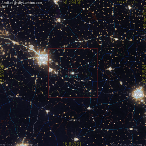

Analysis of Akalkot night lights 2016
Square area 10x10 km:
 1.24%
1.24%90-99
2.07%80-89
0.83%70-79
1.65%60-69
0.83%50-59
0.83%40-49
3.31%30-39
1.65%20-29
3.31%10-19
2.48%0-9
81.82%Square area 50x50 km:
0.45%90-99
0.76%80-89
0.32%70-79
0.58%60-69
0.76%50-59
1.4%40-49
1.45%30-39
1.49%20-29
2.66%10-19
4.2%0-9
85.92%Clear (daylight) street map image can be seen on geolist.org.
Map coordinates:
18° 11' 40.4" North, 75° 30' 10.7" East
17° 31' 31.2" North, 76° 12' 22" East
16° 51' 13" North, 76° 54' 33.3" East
Some cities around Akalkot sort by population:
• Solāpur
35.3 km =21.9 mi,  297°
297°
• Aland
38.7 km =24 mi,  83°
83°
• Indi
47.1 km =29.3 mi,  214°
214°
• Afzalpur
39.7 km =24.7 mi,  155°
155°
• Moram
40.5 km =25.2 mi,  43°
43°
• Naldurg
33.4 km =20.8 mi,  13°
13°
• Dudhani
25.2 km =15.7 mi,  137°
137°
• Maindargi
11.9 km =7.4 mi,  129°
129°
1279147 (p: 39,226)
Sources (retrieved 2019-11-25):
» Earth at Night: Flat Maps 2012, 2016