Maindargi night lights from space
Night Light of Maindargi (Maharashtra) from space (India) Src. Average luminocity for 10x10km area is 1.8657% and for 50x50km: 3.3171%.
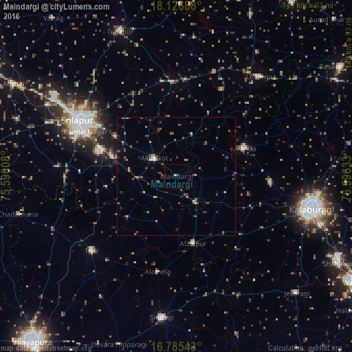
Analysis of Maindargi night lights 2016
Square area 10x10 km:
 0%
0%90-99
0.21%80-89
0.62%70-79
0%60-69
0%50-59
0.83%40-49
0%30-39
0%20-29
0%10-19
0.83%0-9
97.52%Square area 50x50 km:
0.09%90-99
0.25%80-89
0.21%70-79
0.37%60-69
0.38%50-59
0.86%40-49
0.79%30-39
0.77%20-29
1.09%10-19
1.07%0-9
94.11%Clear (daylight) street map image can be seen on geolist.org.
Map coordinates:
18° 7' 36.8" North, 75° 35' 24.3" East
17° 27' 26.6" North, 76° 17' 35.5" East
16° 47' 7.5" North, 76° 59' 46.8" East
Some cities around Maindargi sort by population:
• Solāpur
47 km =29.2 mi,  300°
300°
• Akalkot
11.9 km =7.4 mi,  309°
309°
• Aland
31.5 km =19.6 mi,  67°
67°
• Indi
47.7 km =29.6 mi,  229°
229°
• Afzalpur
29.5 km =18.3 mi,  166°
166°
• Moram
41.3 km =25.7 mi,  27°
27°
• Naldurg
40 km =24.9 mi,  358°
358°
• Dudhani
13.5 km =8.4 mi,  144°
144°
1264297 (p: 11,444)
Sources (retrieved 2019-11-25):
» Earth at Night: Flat Maps 2012, 2016