Mānpur night lights from space
Night Light of Mānpur (Madhya Pradesh) from space (India) Src. Average luminocity for 10x10km area is 17.303% and for 50x50km: 19.8158%.
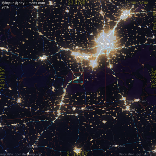
Analysis of Mānpur night lights 2016
Square area 10x10 km:
 0.38%
0.38%90-99
1.89%80-89
1.52%70-79
3.41%60-69
2.27%50-59
2.84%40-49
3.41%30-39
3.22%20-29
2.08%10-19
7.77%0-9
71.21%Square area 50x50 km:
1.95%90-99
4.15%80-89
1.93%70-79
2.91%60-69
2.96%50-59
2.93%40-49
3.7%30-39
3.72%20-29
4.19%10-19
8.24%0-9
63.32%Clear (daylight) street map image can be seen on geolist.org.
Map coordinates:
23° 4' 47.6" North, 74° 55' 4.6" East
22° 25' 53.4" North, 75° 37' 15.9" East
21° 46' 48.3" North, 76° 19' 27.1" East
Some cities around Mānpur sort by population:
• Indore
38.6 km =24 mi,  34°
34°
• Dhār
37.8 km =23.5 mi,  298°
298°
• Pithampur
20.5 km =12.7 mi,  22°
22°
• Dhāmnod
29.2 km =18.1 mi,  212°
212°
• Maheshwar
28.6 km =17.8 mi,  186°
186°
• Kasrāwad
33.8 km =21 mi,  181°
181°
• Betma
28.4 km =17.6 mi,  358°
358°
• Māndleshwar
28.7 km =17.8 mi,  171°
171°
1263636 (p: 6,636)
Sources (retrieved 2019-11-25):
» Earth at Night: Flat Maps 2012, 2016