Betma night lights from space
Night Light of Betma (Madhya Pradesh) from space (India) Src. Average luminocity for 10x10km area is 37.4385% and for 50x50km: 28.223%.
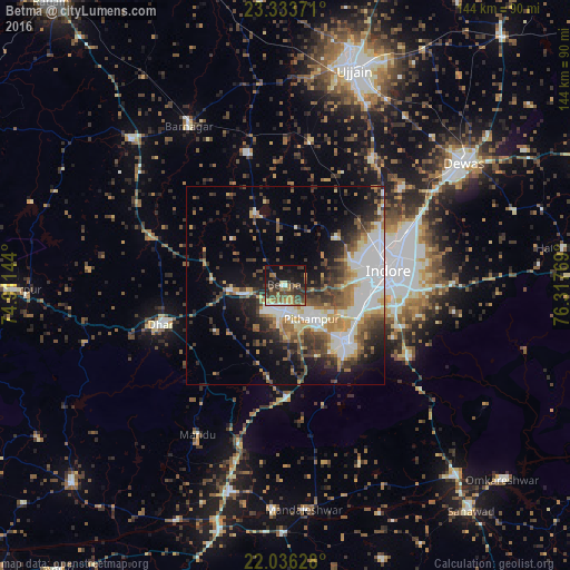
Analysis of Betma night lights 2016
Square area 10x10 km:
 1.59%
1.59%90-99
3.57%80-89
2.58%70-79
5.75%60-69
7.94%50-59
7.14%40-49
12.1%30-39
13.89%20-29
11.11%10-19
25.79%0-9
8.53%Square area 50x50 km:
4.56%90-99
6.44%80-89
2.49%70-79
3.18%60-69
3.77%50-59
3.78%40-49
5.01%30-39
5.55%20-29
5.88%10-19
10.22%0-9
49.14%Clear (daylight) street map image can be seen on geolist.org.
Map coordinates:
23° 20' 1.4" North, 74° 54' 41.2" East
22° 41' 11.5" North, 75° 36' 52.4" East
22° 2' 10.6" North, 76° 19' 3.7" East
Some cities around Betma sort by population:
• Indore
22.7 km =14.1 mi,  81°
81°
• Dhār
34.1 km =21.2 mi,  252°
252°
• Pithampur
12.6 km =7.8 mi,  138°
138°
• Depālpur
19.7 km =12.2 mi,  337°
337°
• Gautampura
34.8 km =21.6 mi, 343°
• Sānwer
38.7 km =24 mi,  34°
34°
• Hātod
17.5 km =10.9 mi,  47°
47°
• Mānpur
28.4 km =17.6 mi,  178°
178°
1276400 (p: 13,817)
Sources (retrieved 2019-11-25):
» Earth at Night: Flat Maps 2012, 2016