Manavālakurichi night lights from space
Night Light of Manavālakurichi (Tamil Nadu) from space (India) Src. Average luminocity for 10x10km area is 14.4525% and for 50x50km: 11.116%.
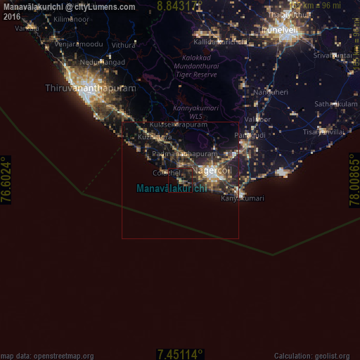
Analysis of Manavālakurichi night lights 2016
Square area 10x10 km:
 0%
0%90-99
0%80-89
0%70-79
0.41%60-69
1.24%50-59
3.72%40-49
5.99%30-39
8.06%20-29
3.72%10-19
23.97%0-9
52.89%Square area 50x50 km:
0.72%90-99
0.93%80-89
0.84%70-79
0.98%60-69
1.86%50-59
1.67%40-49
3.01%30-39
3.8%20-29
3.99%10-19
10.14%0-9
72.05%Clear (daylight) street map image can be seen on geolist.org.
Map coordinates:
8° 50' 35.4" North, 76° 36' 8.6" East
8° 8' 51.9" North, 77° 18' 19.9" East
7° 27' 4.1" North, 78° 0' 31.1" East
Some cities around Manavālakurichi sort by population:
• Nāgercoil
14.4 km =8.9 mi,  76°
76°
• Neyyāttinkara
36.9 km =22.9 mi,  319°
319°
• Colachel
6.3 km =3.9 mi,  304°
304°
• Kuzhithurai
22.7 km =14.1 mi,  326°
326°
• Kanniyākumāri
26.4 km =16.4 mi,  104°
104°
• Padmanābhapuram
11 km =6.8 mi,  11°
11°
• Suchindram
17.8 km =11.1 mi,  87°
87°
• Eraniel
6.6 km =4.1 mi, 11°
1263942 (p: 10,720)
Sources (retrieved 2019-11-25):
» Earth at Night: Flat Maps 2012, 2016