Malīhābād night lights from space
Night Light of Malīhābād (Uttar Pradesh) from space (India) Src. Average luminocity for 10x10km area is 53.2659% and for 50x50km: 35.4144%.
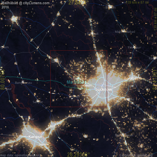
Analysis of Malīhābād night lights 2016
Square area 10x10 km:
 2.58%
2.58%90-99
6.35%80-89
7.74%70-79
8.93%60-69
5.16%50-59
19.84%40-49
17.66%30-39
16.47%20-29
12.7%10-19
2.58%0-9
0%Square area 50x50 km:
9.32%90-99
9.57%80-89
2.94%70-79
3.22%60-69
3.36%50-59
4.02%40-49
4.71%30-39
4.98%20-29
6.48%10-19
9.99%0-9
41.42%Clear (daylight) street map image can be seen on geolist.org.
Map coordinates:
27° 32' 50.6" North, 80° 0' 27.6" East
26° 55' 20" North, 80° 42' 38.8" East
26° 17' 36.9" North, 81° 24' 50.1" East
Some cities around Malīhābād sort by population:
• Lucknow
23 km =14.3 mi,  113°
113°
• Sandīla
25.4 km =15.8 mi,  310°
310°
• Jagdīshpur
25.3 km =15.7 mi,  220°
220°
• Kākori
9.6 km =6 mi,  129°
129°
• Mohān
16.2 km =10.1 mi,  192°
192°
• Rasūlābād
29.5 km =18.3 mi,  227°
227°
• Itaunja
25.7 km =16 mi,  45°
45°
• Aurās
20.1 km =12.5 mi,  267°
267°
1264085 (p: 16,649)
Sources (retrieved 2019-11-25):
» Earth at Night: Flat Maps 2012, 2016