Aurās night lights from space
Night Light of Aurās (Uttar Pradesh) from space (India) Src. Average luminocity for 10x10km area is 0.2421% and for 50x50km: 9.8715%.
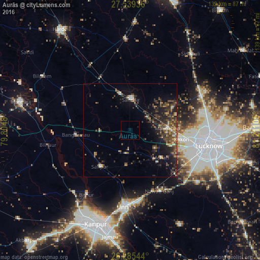
Analysis of Aurās night lights 2016
Square area 10x10 km:
 0%
0%90-99
0%80-89
0%70-79
0%60-69
0%50-59
0%40-49
0%30-39
0%20-29
0%10-19
1.59%0-9
98.41%Square area 50x50 km:
0.52%90-99
0.77%80-89
0.7%70-79
1.22%60-69
1.23%50-59
2.1%40-49
2.93%30-39
2.7%20-29
4.08%10-19
6.49%0-9
77.28%Clear (daylight) street map image can be seen on geolist.org.
Map coordinates:
27° 32' 21.7" North, 79° 48' 17.3" East
26° 54' 50.9" North, 80° 30' 28.5" East
26° 17' 7.6" North, 81° 12' 39.8" East
Some cities around Aurās sort by population:
• Sandīla
17.3 km =10.7 mi,  2°
2°
• Jagdīshpur
18.7 km =11.6 mi,  168°
168°
• Safīpur
25.5 km =15.8 mi,  219°
219°
• Malīhābād
20.1 km =12.5 mi,  87°
87°
• Mohān
22.3 km =13.9 mi,  131°
131°
• Rasūlābād
18.9 km =11.7 mi,  185°
185°
• Ugu
22.7 km =14.1 mi,  234°
234°
• Fatehpur Chaurāsi
27.8 km =17.3 mi,  239°
239°
1278142 (p: 6,591)
Sources (retrieved 2019-11-25):
» Earth at Night: Flat Maps 2012, 2016