Itaunja night lights from space
Night Light of Itaunja (Uttar Pradesh) from space (India) Src. Average luminocity for 10x10km area is 51.5777% and for 50x50km: 31.1683%.
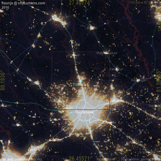
Analysis of Itaunja night lights 2016
Square area 10x10 km:
 3.41%
3.41%90-99
10.8%80-89
8.33%70-79
8.14%60-69
11.17%50-59
4.73%40-49
11.36%30-39
9.85%20-29
19.51%10-19
12.69%0-9
0%Square area 50x50 km:
6.06%90-99
8.32%80-89
2.92%70-79
3.3%60-69
3.71%50-59
4.14%40-49
4.44%30-39
5.5%20-29
6.62%10-19
9.34%0-9
45.64%Clear (daylight) street map image can be seen on geolist.org.
Map coordinates:
27° 42' 27.9" North, 80° 11' 37" East
27° 5' 0.5" North, 80° 53' 48.2" East
26° 27' 20.6" North, 81° 35' 59.5" East
Some cities around Itaunja sort by population:
• Lucknow
27.3 km =17 mi,  174°
174°
• Nawābganj
34.3 km =21.3 mi,  119°
119°
• Mahmudābād
31.9 km =19.8 mi,  43°
43°
• Fatehpur
32.6 km =20.3 mi,  72°
72°
• Sidhaulī
22.9 km =14.2 mi,  344°
344°
• Kākori
26.4 km =16.4 mi,  204°
204°
• Malīhābād
25.7 km =16 mi,  225°
225°
• Dewā
27.3 km =17 mi,  101°
101°
1269652 (p: 6,726)
Sources (retrieved 2019-11-25):
» Earth at Night: Flat Maps 2012, 2016