Malhārgarh night lights from space
Night Light of Malhārgarh (Madhya Pradesh) from space (India) Src. Average luminocity for 10x10km area is 7.1004% and for 50x50km: 9.8316%.
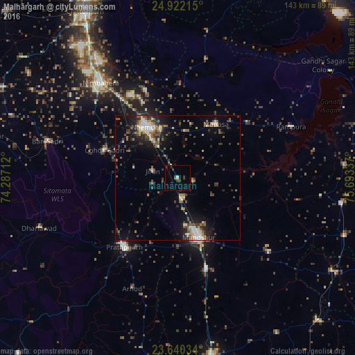
Analysis of Malhārgarh night lights 2016
Square area 10x10 km:
 0%
0%90-99
0.95%80-89
0.19%70-79
0.76%60-69
0.76%50-59
0%40-49
0.95%30-39
3.6%20-29
2.46%10-19
1.89%0-9
88.45%Square area 50x50 km:
0.6%90-99
1.91%80-89
0.7%70-79
0.83%60-69
1.08%50-59
1.8%40-49
1.84%30-39
2.34%20-29
2.82%10-19
5.93%0-9
80.15%Clear (daylight) street map image can be seen on geolist.org.
Map coordinates:
24° 55' 19.7" North, 74° 17' 13.6" East
24° 16' 58.3" North, 74° 59' 24.9" East
23° 38' 25.2" North, 75° 41' 36.1" East
Some cities around Malhārgarh sort by population:
• Mandsaur
24.8 km =15.4 mi,  161°
161°
• Pratāpgarh
35 km =21.7 mi,  217°
217°
• Manāsa
26.5 km =16.5 mi,  35°
35°
• Chhoti Sādri
31.3 km =19.4 mi,  290°
290°
• Jāwad
37.5 km =23.3 mi,  339°
339°
• Sītāmau
47.4 km =29.5 mi,  128°
128°
• Jīran
10.5 km =6.5 mi, 285°
• Nārāyangarh
6.2 km =3.9 mi,  102°
102°
1264099 (p: 7,620)
Sources (retrieved 2019-11-25):
» Earth at Night: Flat Maps 2012, 2016