Jāwad night lights from space
Night Light of Jāwad (Madhya Pradesh) from space (India) Src. Average luminocity for 10x10km area is 22.7202% and for 50x50km: 15.9825%.
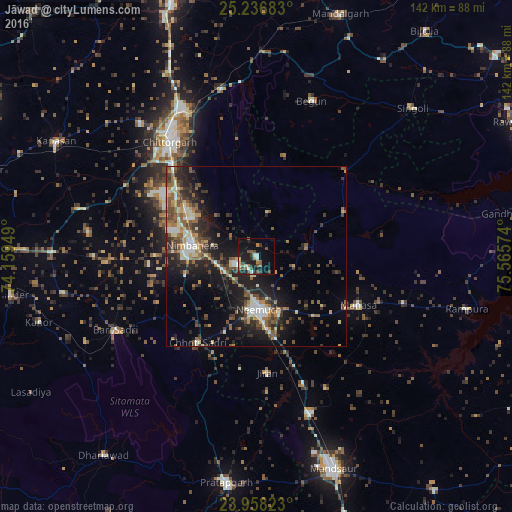
Analysis of Jāwad night lights 2016
Square area 10x10 km:
 0.79%
0.79%90-99
3.57%80-89
2.78%70-79
0.99%60-69
3.17%50-59
4.76%40-49
5.56%30-39
3.37%20-29
6.55%10-19
23.81%0-9
44.64%Square area 50x50 km:
0.81%90-99
2.86%80-89
1.71%70-79
1.64%60-69
2%50-59
3.46%40-49
3.23%30-39
3.38%20-29
5.24%10-19
11.24%0-9
64.42%Clear (daylight) street map image can be seen on geolist.org.
Map coordinates:
25° 14' 12.6" North, 74° 9' 34.2" East
24° 35' 57" North, 74° 51' 45.4" East
23° 57' 29.6" North, 75° 33' 56.7" East
Some cities around Jāwad sort by population:
• Chittaurgarh
40.3 km =25 mi,  323°
323°
• Nīmbāhera
18.6 km =11.6 mi,  277°
277°
• Manāsa
31.2 km =19.4 mi,  115°
115°
• Chhoti Sādri
29.2 km =18.1 mi,  214°
214°
• Jīran
32.4 km =20.1 mi,  174°
174°
• Nārāyangarh
41.1 km =25.5 mi,  152°
152°
• Malhārgarh
37.5 km =23.3 mi,  159°
159°
• Ratangarh
35.3 km =21.9 mi,  46°
46°
1269126 (p: 16,887)
Sources (retrieved 2019-11-25):
» Earth at Night: Flat Maps 2012, 2016