Mādhogarh night lights from space
Night Light of Mādhogarh (Uttar Pradesh) from space (India) Src. Average luminocity for 10x10km area is 9.7381% and for 50x50km: 5.6381%.
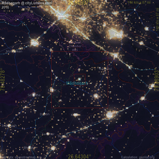
Analysis of Mādhogarh night lights 2016
Square area 10x10 km:
 0.99%
0.99%90-99
0.6%80-89
0.79%70-79
0%60-69
1.59%50-59
1.98%40-49
1.98%30-39
2.58%20-29
3.97%10-19
4.17%0-9
81.35%Square area 50x50 km:
0.28%90-99
0.47%80-89
0.38%70-79
0.41%60-69
0.83%50-59
1.02%40-49
1.61%30-39
1.28%20-29
1.72%10-19
2.34%0-9
89.65%Clear (daylight) street map image can be seen on geolist.org.
Map coordinates:
26° 54' 14.3" North, 78° 28' 58" East
26° 16' 30.8" North, 79° 11' 9.2" East
25° 38' 34.9" North, 79° 53' 20.5" East
Some cities around Mādhogarh sort by population:
• Auraiya
38.5 km =23.9 mi,  56°
56°
• Jālaun
20.9 km =13 mi,  133°
133°
• Konch
31.4 km =19.5 mi,  186°
186°
• Lahār
26 km =16.2 mi,  249°
249°
• Mihona
20.5 km =12.7 mi,  272°
272°
• Rāmpura
8.3 km =5.2 mi,  357°
357°
• Umri
36.1 km =22.4 mi,  316°
316°
• Nadīgaon
24.7 km =15.3 mi,  221°
221°
1264567 (p: 10,530)
Sources (retrieved 2019-11-25):
» Earth at Night: Flat Maps 2012, 2016