Sunel night lights from space
Night Light of Sunel (Rajasthan) from space (India) Src. Average luminocity for 10x10km area is 12.3016% and for 50x50km: 14.4594%.
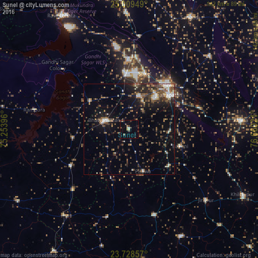
Analysis of Sunel night lights 2016
Square area 10x10 km:
 0.2%
0.2%90-99
0.79%80-89
2.98%70-79
0%60-69
1.59%50-59
2.18%40-49
2.78%30-39
1.79%20-29
0.99%10-19
2.18%0-9
84.52%Square area 50x50 km:
0.92%90-99
1.95%80-89
0.9%70-79
1.31%60-69
1.61%50-59
2.84%40-49
3.59%30-39
3.6%20-29
4.75%10-19
7.48%0-9
71.05%Clear (daylight) street map image can be seen on geolist.org.
Map coordinates:
25° 0' 34.2" North, 75° 15' 14.3" East
24° 22' 14.3" North, 75° 57' 25.5" East
23° 43' 42.9" North, 76° 39' 36.8" East
Some cities around Sunel sort by population:
• Jhālāwār
32.7 km =20.3 mi,  39°
39°
• Bhawāniganj
13.3 km =8.3 mi,  292°
292°
• Rāmganj Mandi
30.7 km =19.1 mi,  357°
357°
• Jhālrapātan
29 km =18 mi,  48°
48°
• Suket
31.8 km =19.8 mi,  15°
15°
• Bhānpura
26.5 km =16.5 mi,  306°
306°
• Pirāwa
25 km =15.5 mi,  163°
163°
• Bakāni
29.9 km =18.6 mi,  108°
108°
1255425 (p: 15,840)
Sources (retrieved 2019-11-25):
» Earth at Night: Flat Maps 2012, 2016