Pirāwa night lights from space
Night Light of Pirāwa (Rajasthan) from space (India) Src. Average luminocity for 10x10km area is 12.0871% and for 50x50km: 6.8388%.
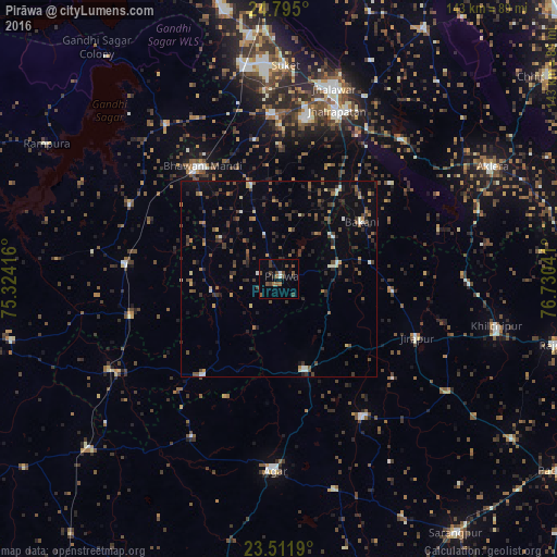
Analysis of Pirāwa night lights 2016
Square area 10x10 km:
 0.38%
0.38%90-99
1.14%80-89
0%70-79
0%60-69
2.27%50-59
3.79%40-49
4.55%30-39
3.79%20-29
1.52%10-19
1.7%0-9
80.87%Square area 50x50 km:
0.2%90-99
0.65%80-89
0.51%70-79
0.56%60-69
0.72%50-59
1.47%40-49
1.55%30-39
2.04%20-29
1.87%10-19
1.93%0-9
88.49%Clear (daylight) street map image can be seen on geolist.org.
Map coordinates:
24° 47' 42" North, 75° 19' 27" East
24° 9' 18.2" North, 76° 1' 38.2" East
23° 30' 42.8" North, 76° 43' 49.5" East
Some cities around Pirāwa sort by population:
• Bhawāniganj
34.9 km =21.7 mi,  326°
326°
• Jhālrapātan
45.5 km =28.3 mi,  18°
18°
• Shāmgarh
39.6 km =24.6 mi,  275°
275°
• Bhānpura
48.9 km =30.4 mi,  324°
324°
• Sunel
25 km =15.5 mi,  343°
343°
• Susner
24 km =14.9 mi,  165°
165°
• Bakāni
25.8 km =16 mi,  55°
55°
• Māchalpur
29.5 km =18.3 mi,  95°
95°
1259540 (p: 11,790)
Sources (retrieved 2019-11-25):
» Earth at Night: Flat Maps 2012, 2016