Kālāgarh Project Colony night lights from space
Night Light of Kālāgarh Project Colony (Uttarakhand) from space (India) Src. Average luminocity for 10x10km area is 6.5947% and for 50x50km: 7.241%.
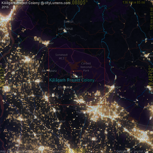
Analysis of Kālāgarh Project Colony night lights 2016
Square area 10x10 km:
 0.38%
0.38%90-99
1.89%80-89
0%70-79
0.76%60-69
0.76%50-59
1.14%40-49
1.89%30-39
0.57%20-29
1.89%10-19
2.08%0-9
88.64%Square area 50x50 km:
0.38%90-99
0.96%80-89
0.75%70-79
0.74%60-69
0.89%50-59
1.08%40-49
1.7%30-39
2.15%20-29
3.02%10-19
5.76%0-9
82.57%Clear (daylight) street map image can be seen on geolist.org.
Map coordinates:
30° 5' 17" North, 78° 4' 52.9" East
29° 28' 40.1" North, 78° 47' 4.2" East
28° 51' 49.9" North, 79° 29' 15.4" East
Some cities around Kālāgarh Project Colony sort by population:
• Kashipur
33.8 km =21 mi,  150°
150°
• Nagīna
33.9 km =21.1 mi,  263°
263°
• Sherkot
26.4 km =16.4 mi,  230°
230°
• Rāmnagar
34.6 km =21.5 mi,  105°
105°
• Dhāmpur
32.5 km =20.2 mi, 234°
• Jaspur
22.5 km =14 mi,  169°
169°
• Thakurdwara
32.6 km =20.3 mi, 166°
• Afzalgarh
14.2 km =8.8 mi, 228°
1268510 (p: 13,298)
Sources (retrieved 2019-11-25):
» Earth at Night: Flat Maps 2012, 2016