Kurgunta night lights from space
Night Light of Kurgunta (Karnataka) from space (India) Src. Average luminocity for 10x10km area is 11.343% and for 50x50km: 13.6355%.
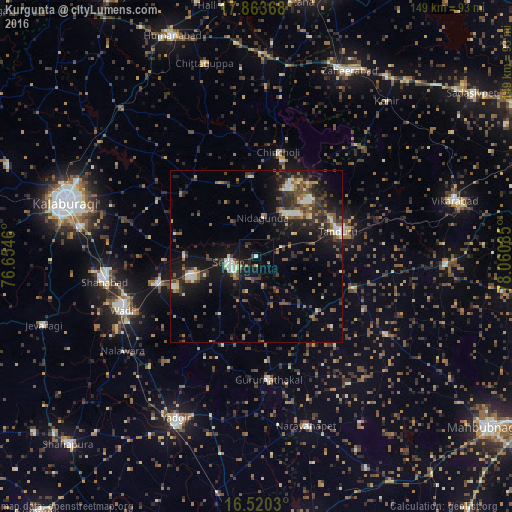
Analysis of Kurgunta night lights 2016
Square area 10x10 km:
 0%
0%90-99
0.83%80-89
0.83%70-79
0.83%60-69
1.65%50-59
0.83%40-49
1.03%30-39
2.27%20-29
7.02%10-19
16.94%0-9
67.77%Square area 50x50 km:
1.23%90-99
1.68%80-89
1.03%70-79
0.75%60-69
2.03%50-59
2.35%40-49
2.83%30-39
3.29%20-29
4.82%10-19
11.21%0-9
68.78%Clear (daylight) street map image can be seen on geolist.org.
Map coordinates:
17° 51' 49.2" North, 76° 39' 16.6" East
17° 11' 35.6" North, 77° 21' 27.8" East
16° 31' 13.1" North, 78° 3' 39.1" East
Some cities around Kurgunta sort by population:
• Tāndūr
24.1 km =15 mi,  75°
75°
• Shāhābād
44.5 km =27.7 mi,  261°
261°
• Nārāyanpet
51.6 km =32.1 mi,  163°
163°
• Seram
7.4 km =4.6 mi, 257°
• Wādi
42.1 km =26.2 mi,  248°
248°
• Chītāpur
30.3 km =18.8 mi, 255°
• Chincholi
30.9 km =19.2 mi,  12°
12°
• Gurmatkāl
36.4 km =22.6 mi,  174°
174°
1265515 (p: 8,682)
Sources (retrieved 2019-11-25):
» Earth at Night: Flat Maps 2012, 2016