Gurmatkāl night lights from space
Night Light of Gurmatkāl (Karnataka) from space (India) Src. Average luminocity for 10x10km area is 13.803% and for 50x50km: 8.0674%.
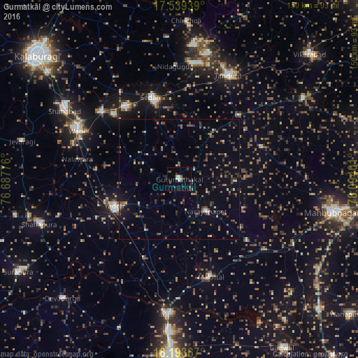
Analysis of Gurmatkāl night lights 2016
Square area 10x10 km:
 1.08%
1.08%90-99
1.52%80-89
1.73%70-79
0.65%60-69
0.22%50-59
1.52%40-49
2.6%30-39
7.14%20-29
2.16%10-19
2.16%0-9
79.22%Square area 50x50 km:
0.19%90-99
0.69%80-89
0.48%70-79
0.45%60-69
1.1%50-59
2.01%40-49
1.99%30-39
2.09%20-29
2.15%10-19
2.29%0-9
86.55%Clear (daylight) street map image can be seen on geolist.org.
Map coordinates:
17° 32' 21.8" North, 76° 41' 15.9" East
16° 52' 3.8" North, 77° 23' 27.2" East
16° 11' 37.2" North, 78° 5' 38.4" East
Some cities around Gurmatkāl sort by population:
• Yādgīr
29.1 km =18.1 mi,  248°
248°
• Tāndūr
46.7 km =29 mi,  25°
25°
• Shāhābād
55.8 km =34.7 mi,  301°
301°
• Nārāyanpet
17.4 km =10.8 mi,  140°
140°
• Seram
36.2 km =22.5 mi,  342°
342°
• Wādi
47.2 km =29.3 mi, 295°
• Chītāpur
43.4 km =27 mi,  310°
310°
• Kurgunta
36.4 km =22.6 mi,  354°
354°
1270627 (p: 18,236)
Sources (retrieved 2019-11-25):
» Earth at Night: Flat Maps 2012, 2016