Kunnumma night lights from space
Night Light of Kunnumma (Kerala) from space (India) Src. Average luminocity for 10x10km area is 1.2186% and for 50x50km: 3.8033%.
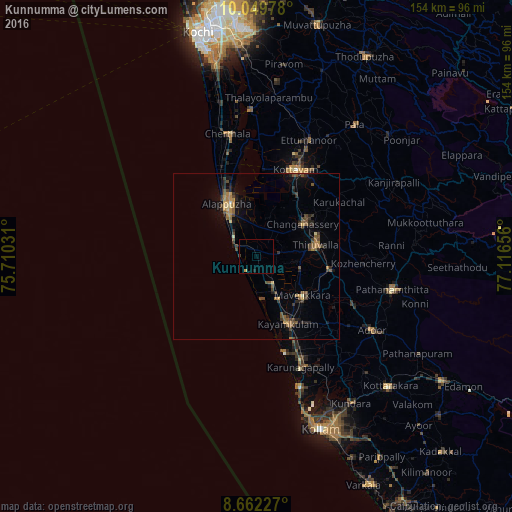
Analysis of Kunnumma night lights 2016
Square area 10x10 km:
 0%
0%90-99
0%80-89
0%70-79
0.87%60-69
0%50-59
0%40-49
0.22%30-39
0.22%20-29
0.87%10-19
0%0-9
97.84%Square area 50x50 km:
0.02%90-99
0.09%80-89
0.27%70-79
0.53%60-69
0.71%50-59
1.02%40-49
0.89%30-39
0.84%20-29
1.17%10-19
1.63%0-9
92.83%Clear (daylight) street map image can be seen on geolist.org.
Map coordinates:
10° 2' 59.2" North, 75° 42' 37.1" East
9° 21' 24.2" North, 76° 24' 48.3" East
8° 39' 44.2" North, 77° 6' 59.6" East
Some cities around Kunnumma sort by population:
• Alappuzha
17.6 km =10.9 mi,  327°
327°
• Kāyankulam
21.7 km =13.5 mi,  153°
153°
• Tiruvalla
17.9 km =11.1 mi,  81°
81°
• Changanācheri
16.5 km =10.3 mi,  54°
54°
• Kalavoor
25.6 km =15.9 mi,  338°
338°
• Māvelikara
19.1 km =11.9 mi,  124°
124°
• Chengannūr
22.6 km =14 mi,  101°
101°
• Kattanam
26 km =16.2 mi,  140°
140°
10793684 (p: 14,918)
Sources (retrieved 2019-11-25):
» Earth at Night: Flat Maps 2012, 2016