Kunnattūr night lights from space
Night Light of Kunnattūr (Tamil Nadu) from space (India) Src. Average luminocity for 10x10km area is 3.4483% and for 50x50km: 6.8992%.
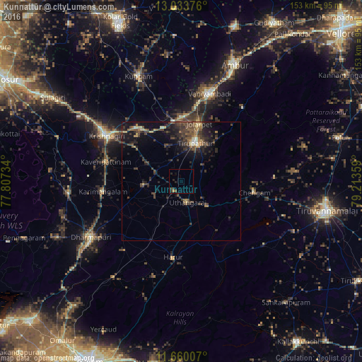
Analysis of Kunnattūr night lights 2016
Square area 10x10 km:
 0%
0%90-99
0%80-89
0%70-79
0.83%60-69
0%50-59
0.83%40-49
0.83%30-39
1.45%20-29
3.1%10-19
1.24%0-9
91.74%Square area 50x50 km:
0.07%90-99
0.34%80-89
0.68%70-79
0.56%60-69
1.02%50-59
1.2%40-49
2.65%30-39
2.37%20-29
2.97%10-19
5.82%0-9
82.32%Clear (daylight) street map image can be seen on geolist.org.
Map coordinates:
13° 2' 1.5" North, 77° 48' 26.4" East
12° 20' 52.2" North, 78° 30' 37.7" East
11° 39' 36.3" North, 79° 12' 48.9" East
Some cities around Kunnattūr sort by population:
• Vaniyambadi
39 km =24.2 mi,  17°
17°
• Krishnagiri
37.4 km =23.2 mi,  300°
300°
• Dharmapuri
45.5 km =28.3 mi,  237°
237°
• Jalārpet
25.7 km =16 mi, 15°
• Chengam
30.8 km =19.1 mi,  98°
98°
• Harūr
33 km =20.5 mi,  185°
185°
• Alangāyam
40.2 km =25 mi,  40°
40°
• Kāveripatnam
32.7 km =20.3 mi,  284°
284°
1265577 (p: 7,326)
Sources (retrieved 2019-11-25):
» Earth at Night: Flat Maps 2012, 2016