Kishangarh night lights from space
Night Light of Kishangarh (Rajasthan) from space (India) Src. Average luminocity for 10x10km area is 17.7045% and for 50x50km: 8.244%.
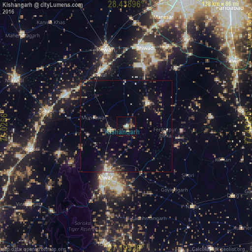
Analysis of Kishangarh night lights 2016
Square area 10x10 km:
 1.52%
1.52%90-99
0.76%80-89
0.76%70-79
1.52%60-69
5.49%50-59
1.89%40-49
5.68%30-39
3.22%20-29
3.22%10-19
6.44%0-9
69.51%Square area 50x50 km:
0.21%90-99
0.76%80-89
0.81%70-79
0.58%60-69
0.96%50-59
1.42%40-49
1.95%30-39
2.5%20-29
2.97%10-19
4.21%0-9
83.63%Clear (daylight) street map image can be seen on geolist.org.
Map coordinates:
28° 26' 20.3" North, 76° 1' 35.8" East
27° 49' 8" North, 76° 43' 47" East
27° 11' 42.9" North, 77° 25' 58.3" East
Some cities around Kishangarh sort by population:
• Alwar
30.3 km =18.8 mi,  199°
199°
• Rewāri
43.7 km =27.2 mi,  345°
345°
• Dhāruhera
43.5 km =27 mi,  8°
8°
• Tijāra
17.8 km =11.1 mi,  43°
43°
• Fīrozpur Jhirka
21.4 km =13.3 mi,  99°
99°
• Bāwal
31.6 km =19.6 mi,  332°
332°
• Nūh
41.3 km =25.7 mi, 40°
• Mandāwar
18.4 km =11.4 mi,  285°
285°
1266484 (p: 10,288)
Sources (retrieved 2019-11-25):
» Earth at Night: Flat Maps 2012, 2016