Nūh night lights from space
Night Light of Nūh (Haryana) from space (India) Src. Average luminocity for 10x10km area is 13.3958% and for 50x50km: 21.4836%.
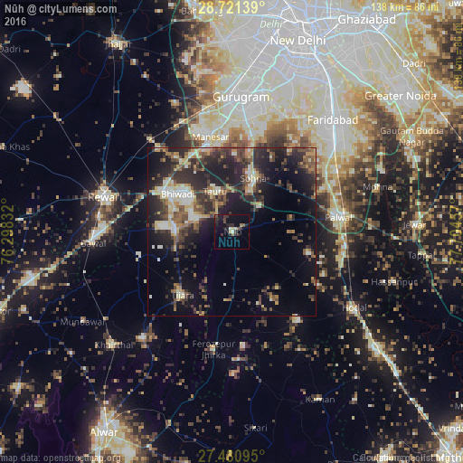
Analysis of Nūh night lights 2016
Square area 10x10 km:
100  0%
0%
90-99 2.27%
80-89 0.76%
70-79 0.76%
60-69 0.95%
50-59 1.33%
40-49 3.22%
30-39 4.73%
20-29 5.68%
10-19 10.98%
0-9 69.32%
0%90-99
2.27%80-89
0.76%70-79
0.76%60-69
0.95%50-59
1.33%40-49
3.22%30-39
4.73%20-29
5.68%10-19
10.98%0-9
69.32%Square area 50x50 km:
100 1.71%
90-99 2.97%
80-89 2.95%
70-79 1.98%
60-69 2.25%
50-59 3.57%
40-49 4.68%
30-39 5.5%
20-29 9.6%
10-19 13.22%
0-9 51.56%
1.71%90-99
2.97%80-89
2.95%70-79
1.98%60-69
2.25%50-59
3.57%40-49
4.68%30-39
5.5%20-29
9.6%10-19
13.22%0-9
51.56%Clear (daylight) street map image can be seen on geolist.org.
Map coordinates:
28° 43' 17" North, 76° 17' 54" East
28° 6' 10.7" North, 77° 0' 5.2" East
27° 28' 51.4" North, 77° 42' 16.5" East
Some cities around Nūh sort by population:
• Palwal
32.1 km =19.9 mi,  81°
81°
• Bhiwadi
18.2 km =11.3 mi,  310°
310°
• Sohna
17.2 km =10.7 mi,  21°
21°
• Dhāruhera
23.1 km =14.4 mi,  299°
299°
• Tijāra
23.6 km =14.7 mi,  217°
217°
• Tāoru
13.1 km =8.1 mi,  337°
337°
• Pataudi
33 km =20.5 mi,  318°
318°
• Pūnāhāna
33.2 km =20.6 mi,  143°
143°
1261145 (p: 12,698)
Sources (retrieved 2019-11-25):
» Earth at Night: Flat Maps 2012, 2016