Khatīma night lights from space
Night Light of Khatīma (Uttarakhand) from space (India) Src. Average luminocity for 10x10km area is 27.5933% and for 50x50km: 5.4762%.
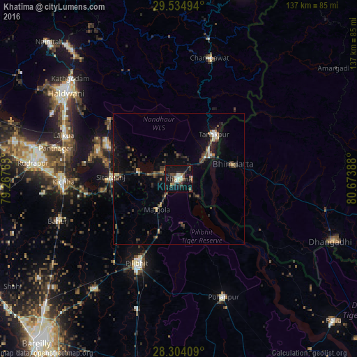
Analysis of Khatīma night lights 2016
Square area 10x10 km:
 1.79%
1.79%90-99
4.96%80-89
3.57%70-79
0.79%60-69
2.98%50-59
2.38%40-49
7.34%30-39
6.15%20-29
8.93%10-19
44.64%0-9
16.47%Square area 50x50 km:
0.25%90-99
0.52%80-89
0.46%70-79
0.2%60-69
0.69%50-59
0.81%40-49
1.42%30-39
1.46%20-29
1.61%10-19
5.33%0-9
87.26%Clear (daylight) street map image can be seen on geolist.org.
Map coordinates:
29° 32' 5.8" North, 79° 16' 3.5" East
28° 55' 16.8" North, 79° 58' 14.7" East
28° 18' 14.7" North, 80° 40' 26" East
Some cities around Khatīma sort by population:
• Pīlibhīt
36.1 km =22.4 mi,  206°
206°
• Mahendranagar, NP
20.6 km =12.8 mi,  76°
76°
• Kichha
43.9 km =27.3 mi,  268°
268°
• Sitārganj
25.9 km =16.1 mi, 271°
• Tanakpur
21.8 km =13.5 mi,  38°
38°
• Jahānābād
40.7 km =25.3 mi,  217°
217°
• Kālīnagar
35.2 km =21.9 mi,  162°
162°
• Banbasa
12.9 km =8 mi,  52°
52°
1266843 (p: 15,714)
Sources (retrieved 2019-11-25):
» Earth at Night: Flat Maps 2012, 2016