Banbasa night lights from space
Night Light of Banbasa (Uttar Pradesh) from space (India) Src. Average luminocity for 10x10km area is 18.4048% and for 50x50km: 4.1728%.
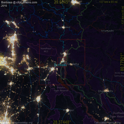
Analysis of Banbasa night lights 2016
Square area 10x10 km:
 1.98%
1.98%90-99
3.37%80-89
0.6%70-79
0.4%60-69
1.98%50-59
3.97%40-49
4.96%30-39
3.97%20-29
0.99%10-19
15.87%0-9
61.9%Square area 50x50 km:
0.23%90-99
0.48%80-89
0.32%70-79
0.14%60-69
0.57%50-59
0.6%40-49
1.1%30-39
1.03%20-29
1.19%10-19
3.84%0-9
90.49%Clear (daylight) street map image can be seen on geolist.org.
Map coordinates:
29° 36' 16.2" North, 79° 22' 22.7" East
28° 59' 28.8" North, 80° 4' 33.9" East
28° 22' 28.1" North, 80° 46' 45.2" East
Some cities around Banbasa sort by population:
• Pīlibhīt
48 km =29.8 mi,  213°
213°
• Mahendranagar, NP
10.3 km =6.4 mi,  107°
107°
• Sitārganj
36.8 km =22.9 mi,  259°
259°
• Tanakpur
9.8 km =6.1 mi,  20°
20°
• Khatīma
12.9 km =8 mi,  232°
232°
• Jahānābād
53.2 km =33.1 mi,  220°
220°
• Kālīnagar
41.3 km =25.7 mi,  179°
179°
• Lohaghāt
45.9 km =28.5 mi,  1°
1°
7117985 (p: 7,138)
Sources (retrieved 2019-11-25):
» Earth at Night: Flat Maps 2012, 2016