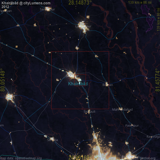
Khairābād night lights from space
Night Light of Khairābād (Uttar Pradesh) from space (India) Src. Average luminocity for 10x10km area is 34.7401% and for 50x50km: 7.1394%.
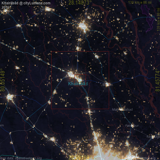
Analysis of Khairābād night lights 2016
Square area 10x10 km:
 2.78%
2.78%90-99
9.52%80-89
1.19%70-79
7.74%60-69
2.58%50-59
1.98%40-49
6.94%30-39
7.14%20-29
12.3%10-19
27.78%0-9
20.04%Square area 50x50 km:
0.51%90-99
1.24%80-89
0.39%70-79
0.53%60-69
0.72%50-59
0.81%40-49
1.64%30-39
1.95%20-29
2.41%10-19
4.65%0-9
85.15%Clear (daylight) street map image can be seen on geolist.org.
Map coordinates:
28° 8' 55.4" North, 80° 3' 5.4" East
27° 31' 37.1" North, 80° 45' 16.6" East
26° 54' 6.1" North, 81° 27' 27.9" East
Some cities around Khairābād sort by population:
• Sītāpur
8.1 km =5 mi,  298°
298°
• Lāharpur
24.9 km =15.5 mi,  35°
35°
• Biswān
24.1 km =15 mi,  98°
98°
• Kheri
42.1 km =26.2 mi,  5°
5°
• Sidhaulī
28.4 km =17.6 mi,  163°
163°
• Maholi
31.6 km =19.6 mi, 298°
• Misrikh
24.4 km =15.2 mi,  244°
244°
• Benīganj
40.2 km =25 mi,  229°
229°
1267175 (p: 42,125)
Sources (retrieved 2019-11-25):
» Earth at Night: Flat Maps 2012, 2016