Misrikh night lights from space
Night Light of Misrikh (Uttar Pradesh) from space (India) Src. Average luminocity for 10x10km area is 9.8258% and for 50x50km: 5.4945%.
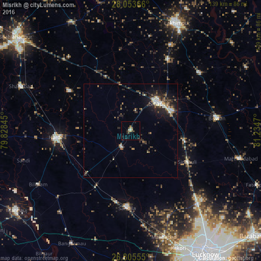
Analysis of Misrikh night lights 2016
Square area 10x10 km:
 0%
0%90-99
1.52%80-89
0.76%70-79
1.33%60-69
1.7%50-59
0.19%40-49
2.46%30-39
2.84%20-29
2.65%10-19
2.84%0-9
83.71%Square area 50x50 km:
0.38%90-99
1.06%80-89
0.3%70-79
0.61%60-69
0.62%50-59
0.38%40-49
1.19%30-39
1.47%20-29
2.16%10-19
3.71%0-9
88.11%Clear (daylight) street map image can be seen on geolist.org.
Map coordinates:
28° 3' 13.2" North, 79° 49' 42.4" East
27° 25' 52.9" North, 80° 31' 53.7" East
26° 48' 20" North, 81° 14' 4.9" East
Some cities around Misrikh sort by population:
• Sītāpur
20.8 km =12.9 mi,  45°
45°
• Hardoī
39.7 km =24.7 mi,  264°
264°
• Khairābād
24.4 km =15.2 mi,  64°
64°
• Pihānī
38.6 km =24 mi,  302°
302°
• Sidhaulī
34.2 km =21.3 mi,  119°
119°
• Maholi
26.5 km =16.5 mi,  347°
347°
• Gopāmau
26.9 km =16.7 mi, 295°
• Benīganj
17.7 km =11 mi,  209°
209°
1262988 (p: 15,007)
Sources (retrieved 2019-11-25):
» Earth at Night: Flat Maps 2012, 2016