Benīganj night lights from space
Night Light of Benīganj (Uttar Pradesh) from space (India) Src. Average luminocity for 10x10km area is 1.7652% and for 50x50km: 2.6712%.
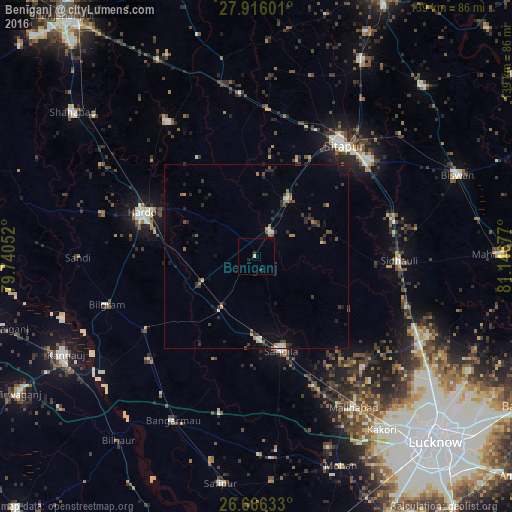
Analysis of Benīganj night lights 2016
Square area 10x10 km:
 0%
0%90-99
0.57%80-89
0.19%70-79
0%60-69
0%50-59
0%40-49
0%30-39
0.76%20-29
1.52%10-19
0%0-9
96.97%Square area 50x50 km:
0.16%90-99
0.24%80-89
0.14%70-79
0.28%60-69
0.38%50-59
0.2%40-49
0.54%30-39
0.86%20-29
1.11%10-19
1.22%0-9
94.88%Clear (daylight) street map image can be seen on geolist.org.
Map coordinates:
27° 54' 57.6" North, 79° 44' 25.9" East
27° 17' 34.5" North, 80° 26' 37.1" East
26° 39' 58.8" North, 81° 8' 48.4" East
Some cities around Benīganj sort by population:
• Sītāpur
38.1 km =23.7 mi,  38°
38°
• Hardoī
32.8 km =20.4 mi,  290°
290°
• Sandīla
25.8 km =16 mi,  164°
164°
• Khairābād
40.2 km =25 mi,  49°
49°
• Sidhaulī
38.6 km =24 mi,  91°
91°
• Misrikh
17.7 km =11 mi,  29°
29°
• Gopāmau
31.1 km =19.3 mi,  329°
329°
• Mādhoganj
35.7 km =22.2 mi,  237°
237°
1276463 (p: 10,418)
Sources (retrieved 2019-11-25):
» Earth at Night: Flat Maps 2012, 2016