Kenda night lights from space
Night Light of Kenda (West Bengal) from space (India) Src. Average luminocity for 10x10km area is 1.5928% and for 50x50km: 4.1149%.
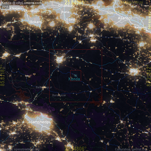
Analysis of Kenda night lights 2016
Square area 10x10 km:
 0%
0%90-99
0%80-89
0%70-79
0%60-69
0%50-59
0%40-49
0.76%30-39
0%20-29
2.65%10-19
2.27%0-9
94.32%Square area 50x50 km:
0.51%90-99
0.56%80-89
0.19%70-79
0.16%60-69
0.31%50-59
0.48%40-49
1.02%30-39
1.36%20-29
1.91%10-19
3.44%0-9
90.07%Clear (daylight) street map image can be seen on geolist.org.
Map coordinates:
23° 50' 26.2" North, 85° 48' 42.7" East
23° 11' 45.2" North, 86° 30' 54" East
22° 32' 53" North, 87° 13' 5.2" East
Some cities around Kenda sort by population:
• Puruliya
21.6 km =13.4 mi,  313°
313°
• Pāthardih
52.9 km =32.9 mi,  350°
350°
• Lakhyabad
54.6 km =33.9 mi,  16°
16°
• Balarāmpur
31.8 km =19.8 mi,  249°
249°
• Raghunathpur
41.4 km =25.7 mi, 22°
• Adra
37.6 km =23.4 mi,  27°
27°
• Khātra
42.5 km =26.4 mi,  125°
125°
• Bhojudih
49.9 km =31 mi, 351°
1267290 (p: 15,131)
Sources (retrieved 2019-11-25):
» Earth at Night: Flat Maps 2012, 2016