Khātra night lights from space
Night Light of Khātra (West Bengal) from space (India) Src. Average luminocity for 10x10km area is 13.4306% and for 50x50km: 3.4163%.
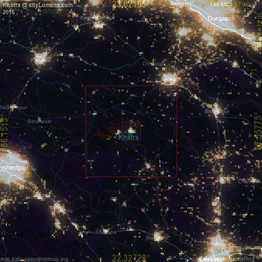
Analysis of Khātra night lights 2016
Square area 10x10 km:
 1.19%
1.19%90-99
2.78%80-89
0.79%70-79
0.99%60-69
2.38%50-59
1.19%40-49
1.19%30-39
1.79%20-29
2.98%10-19
4.76%0-9
79.96%Square area 50x50 km:
0.08%90-99
0.24%80-89
0.18%70-79
0.22%60-69
0.29%50-59
0.54%40-49
0.96%30-39
1.11%20-29
2.3%10-19
2.08%0-9
92.02%Clear (daylight) street map image can be seen on geolist.org.
Map coordinates:
23° 37' 19" North, 86° 9' 5.4" East
22° 58' 34.2" North, 86° 51' 16.6" East
22° 19' 38.2" North, 87° 33' 27.9" East
Some cities around Khātra sort by population:
• Bānkura
36.1 km =22.4 mi,  37°
37°
• Bishnupur
48.8 km =30.3 mi,  77°
77°
• Jhārgrām
59.8 km =37.2 mi,  166°
166°
• Ghātsīla
58.2 km =36.2 mi,  221°
221°
• Āmlāgora
51.3 km =31.9 mi,  106°
106°
• Kenda
42.5 km =26.4 mi,  305°
305°
• Chākuliā
56.6 km =35.2 mi,  194°
194°
• Beliātor
53.6 km =33.3 mi, 44°
1266838 (p: 16,484)
Sources (retrieved 2019-11-25):
» Earth at Night: Flat Maps 2012, 2016