Bhojudih night lights from space
Night Light of Bhojudih (Jharkhand) from space (India) Src. Average luminocity for 10x10km area is 75.998% and for 50x50km: 44.5981%.
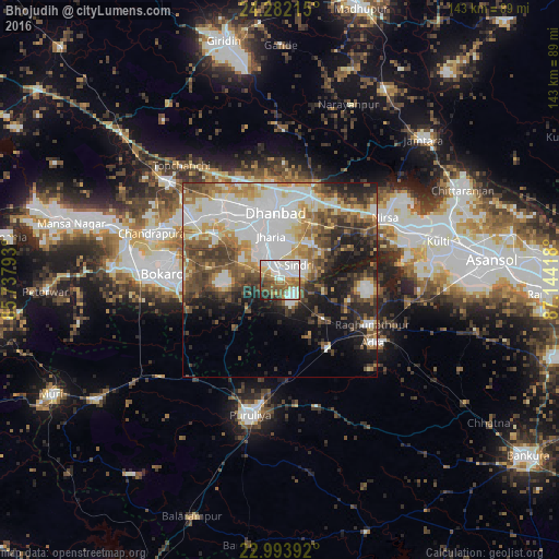
Analysis of Bhojudih night lights 2016
Square area 10x10 km:
 23.21%
90-99
22.02%80-89
6.15%70-79
4.76%60-69
14.48%50-59
14.09%40-49
7.74%30-39
3.17%20-29
3.97%10-19
0.4%0-9
0%Square area 50x50 km:
11.42%90-99
10%80-89
4.43%70-79
4.76%60-69
5.69%50-59
6.19%40-49
7.33%30-39
6.06%20-29
7.21%10-19
10.68%0-9
26.25%Clear (daylight) street map image can be seen on geolist.org.
Map coordinates:
24° 16' 55.7" North, 85° 44' 16.5" East
23° 38' 22.6" North, 86° 26' 27.8" East
22° 59' 38.1" North, 87° 8' 39" East
Some cities around Bhojudih sort by population:
• Dhanbād
18.1 km =11.2 mi,  0°
0°
• Jharia
11.6 km =7.2 mi,  346°
346°
• Pāthardih
3.1 km =1.9 mi,  341°
341°
• Jāmadoba
9.5 km =5.9 mi,  333°
333°
• Sijua
18.9 km =11.7 mi,  323°
323°
• Malkera
22.2 km =13.8 mi, 315°
• Bagra
16.4 km =10.2 mi,  309°
309°
• Kenduadīh
16.5 km =10.3 mi, 336°
1275866 (p: 9,109)
Sources (retrieved 2019-11-25):
» Earth at Night: Flat Maps 2012, 2016