Kadod night lights from space
Night Light of Kadod (Gujarat) from space (India) Src. Average luminocity for 10x10km area is 3.746% and for 50x50km: 16.3802%.
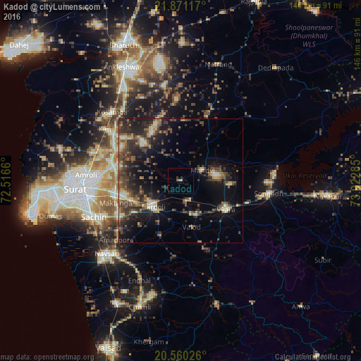
Analysis of Kadod night lights 2016
Square area 10x10 km:
100  0%
0%
90-99 0%
80-89 0.79%
70-79 0.79%
60-69 0%
50-59 0.79%
40-49 0%
30-39 0.79%
20-29 0.79%
10-19 2.78%
0-9 93.25%
0%90-99
0%80-89
0.79%70-79
0.79%60-69
0%50-59
0.79%40-49
0%30-39
0.79%20-29
0.79%10-19
2.78%0-9
93.25%Square area 50x50 km:
100 0.36%
90-99 1.92%
80-89 1.89%
70-79 1.7%
60-69 1.99%
50-59 3.18%
40-49 4.03%
30-39 5.4%
20-29 6.53%
10-19 11.85%
0-9 61.14%
0.36%90-99
1.92%80-89
1.89%70-79
1.7%60-69
1.99%50-59
3.18%40-49
4.03%30-39
5.4%20-29
6.53%10-19
11.85%0-9
61.14%Clear (daylight) street map image can be seen on geolist.org.
Map coordinates:
21° 52' 16.2" North, 72° 30' 59.8" East
21° 13' 1.8" North, 73° 13' 11" East
20° 33' 36.9" North, 73° 55' 22.3" East
Some cities around Kadod sort by population:
• Bārdoli
15.3 km =9.5 mi,  226°
226°
• Vyāra
21.6 km =13.4 mi,  123°
123°
• Kosamba
38.4 km =23.9 mi,  315°
315°
• Songadh
36 km =22.4 mi,  98°
98°
• Māndvi
9.7 km =6 mi,  64°
64°
• Kāthor
30 km =18.6 mi,  285°
285°
• Utrān
36.6 km =22.7 mi,  272°
272°
• Sachīn
37.9 km =23.5 mi,  247°
247°
1268667 (p: 16,747)
Sources (retrieved 2019-11-25):
» Earth at Night: Flat Maps 2012, 2016