Joshīmath night lights from space
Night Light of Joshīmath (Uttarakhand) from space (India) Src. Average luminocity for 10x10km area is 17.2234% and for 50x50km: 1.8298%.
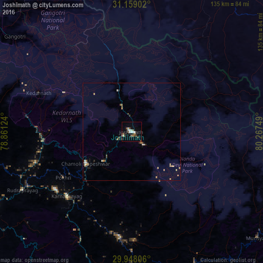
Analysis of Joshīmath night lights 2016
Square area 10x10 km:
 3.11%
3.11%90-99
3.48%80-89
0.73%70-79
0%60-69
2.38%50-59
3.66%40-49
2.93%30-39
1.65%20-29
0.73%10-19
6.78%0-9
74.54%Square area 50x50 km:
0.17%90-99
0.32%80-89
0.05%70-79
0.33%60-69
0.31%50-59
0.33%40-49
0.23%30-39
0.28%20-29
0.23%10-19
0.5%0-9
97.25%Clear (daylight) street map image can be seen on geolist.org.
Map coordinates:
31° 9' 32.5" North, 78° 51' 40.5" East
30° 33' 19.5" North, 79° 33' 51.7" East
29° 56' 53" North, 80° 16' 3" East
Some cities around Joshīmath sort by population:
• Almora
106.9 km =66.4 mi,  175°
175°
• Tehri
105.5 km =65.6 mi,  260°
260°
• Pauri
87.8 km =54.6 mi,  239°
239°
• Srīnagar
83.6 km =51.9 mi, 243°
• Rānikhet
102.5 km =63.7 mi,  187°
187°
• Uttarkāshi
109 km =67.7 mi,  280°
280°
• Bāgeshwar
82.3 km =51.1 mi,  165°
165°
• Lansdowne
116.3 km =72.3 mi,  226°
226°
1268814 (p: 13,865)
Sources (retrieved 2019-11-25):
» Earth at Night: Flat Maps 2012, 2016