Jasrāna night lights from space
Night Light of Jasrāna (Uttar Pradesh) from space (India) Src. Average luminocity for 10x10km area is 10.0682% and for 50x50km: 11.6598%.
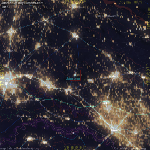
Analysis of Jasrāna night lights 2016
Square area 10x10 km:
 0.19%
0.19%90-99
1.33%80-89
0%70-79
0%60-69
0%50-59
1.52%40-49
3.41%30-39
3.22%20-29
8.52%10-19
5.3%0-9
76.52%Square area 50x50 km:
0.5%90-99
1.04%80-89
0.88%70-79
0.96%60-69
1.41%50-59
1.88%40-49
3.38%30-39
3.08%20-29
4.55%10-19
11.22%0-9
71.09%Clear (daylight) street map image can be seen on geolist.org.
Map coordinates:
27° 51' 33.4" North, 77° 56' 57.6" East
27° 14' 9.1" North, 78° 39' 8.8" East
26° 36' 32.2" North, 79° 21' 20.1" East
Some cities around Jasrāna sort by population:
• Fīrozābād
26.9 km =16.7 mi,  249°
249°
• Shikohābād
15.6 km =9.7 mi,  204°
204°
• Mainpuri
37.2 km =23.1 mi,  91°
91°
• Sirsāganj
20.2 km =12.6 mi,  170°
170°
• Karhal
38.6 km =24 mi,  132°
132°
• Ghiror
14.9 km =9.3 mi,  110°
110°
• Sakīt
25.4 km =15.8 mi,  29°
29°
• Pharihā
20.2 km =12.6 mi,  298°
298°
1269165 (p: 9,883)
Sources (retrieved 2019-11-25):
» Earth at Night: Flat Maps 2012, 2016