Jasidih night lights from space
Night Light of Jasidih (Jharkhand) from space (India) Src. Average luminocity for 10x10km area is 70.4663% and for 50x50km: 14.4948%.
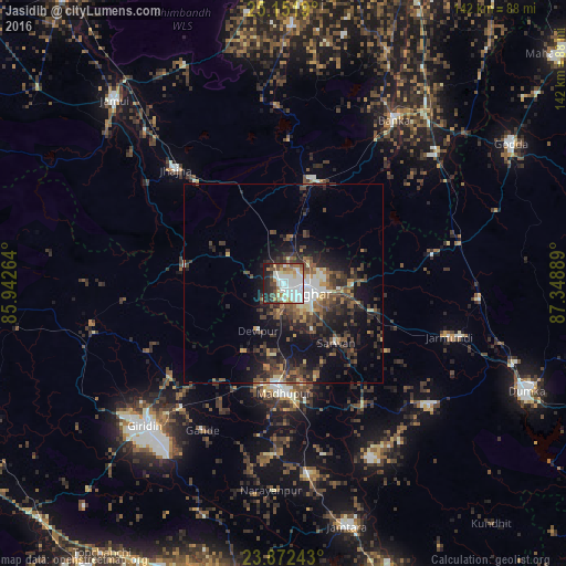
Analysis of Jasidih night lights 2016
Square area 10x10 km:
 23.41%
90-99
22.02%80-89
5.56%70-79
6.35%60-69
7.74%50-59
4.76%40-49
8.53%30-39
3.77%20-29
9.13%10-19
8.73%0-9
0%Square area 50x50 km:
1.73%90-99
2.05%80-89
1.07%70-79
1.12%60-69
1.68%50-59
2.78%40-49
3.38%30-39
3.87%20-29
5.08%10-19
9.73%0-9
67.5%Clear (daylight) street map image can be seen on geolist.org.
Map coordinates:
25° 9' 6.8" North, 85° 56' 33.5" East
24° 30' 49.6" North, 86° 38' 44.7" East
23° 52' 20.7" North, 87° 20' 56" East
Some cities around Jasidih sort by population:
• Jamūī
62.5 km =38.8 mi,  317°
317°
• Gīrīdīh
49.9 km =31 mi,  223°
223°
• Madhupur
26.6 km =16.5 mi,  181°
181°
• Dumka
66.9 km =41.6 mi,  114°
114°
• Bānka
49.5 km =30.8 mi,  34°
34°
• Jhā-Jhā
39.3 km =24.4 mi, 316°
• Jāmtāra
63.3 km =39.3 mi,  165°
165°
• Amarpur
64 km =39.8 mi,  23°
23°
1269175 (p: 16,338)
Sources (retrieved 2019-11-25):
» Earth at Night: Flat Maps 2012, 2016